
The Harbour and the Hinterland

Updated: Aug 30
Issue 01 · Trade · 1.2650° N, 103.8400° E
The shape of growth is a loop.

1.2650° N, 103.8400° E. The pin falls into the Singapore Strait.
A harbour becomes an economy only when what leaves by sea returns as something more valuable.
Odisha preserves the memory of a voyage, the Banda Islands reveal what happens when trade loses reciprocity, and Singapore demonstrates how a place can retain value from goods it does not produce. Across the same ocean, each asks what remains after the ship has gone.
At 1.2650 degrees north and 103.8400 degrees east, the map pin falls into the narrow water between Singapore and Sentosa. Nothing in that patch of blue announces itself as economic history, yet Keppel Harbour has carried tin, rubber, oil, electronics and, eventually, the steel container that taught the world to pack almost everything into the same rectangular grammar. The land around it has been reclaimed, razed, rebuilt and automated. The water has remained the opening through which Singapore enters the world.
Ships passing Keppel no longer wait for the monsoon. They wait for a berth, a customs clearance, a feeder connection and a place in a schedule calculated to the hour. When attacks in the Red Sea forced vessels around the Cape of Good Hope in 2024, ships reached Asian ports late and in bunches. Containers missed onward connections, berths filled and timetables constructed across several oceans began to unravel. Singapore reopened berths at the old Keppel Terminal and accelerated capacity at Tuas. It was later called a “port where schedules catch up”, a place where shipping lines recover lost time and put their networks back into rhythm.
That phrase tells us more about Singapore than the familiar photographs of its skyline. Near the end of the 1950s, nearly 70 per cent of the population lived in slums and unemployment was in double digits. In 1965, separation from Malaysia removed the common market on which the new country had expected to rely. Today, GDP per person approaches US$100,000. Geography, clean government and a capable state belong in every explanation of that ascent, but they do not quite describe the mechanism. Singapore became prosperous by learning how to organise the interval between one place and another, turning delay, uncertainty and passage into services for which the world would pay.
Yet the port that now sells certainty belongs to a maritime world once governed by uncertainty. Long before a ship could steam against the wind or recover a lost day at Tuas, an entire season's commerce depended on reading the sky correctly and leaving home at the appointed moment. That older arrangement survives west across the Bay of Bengal, not in a ledger but in a ritual performed before sunrise on the banks of the Mahanadi.
The voyage that survived the ship
On Kartika Purnima, the day of the full moon of the Hindu month of Kartika, families across Odisha reach rivers, ponds and temple tanks while the morning is still dark. Some carry boats folded from paper. Others have cut them from banana bark or shaped them from cork. A lamp flickers inside beside flowers, a betel leaf and an areca nut. Along the Mahanadi in Cuttack, hundreds of these small vessels gather into a trembling flotilla, and only after they have been given to the water does Bali Jatra, literally “the voyage to Bali”, begin on land.
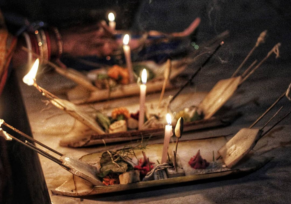
At the water's edge, people recite words older than anyone speaking them.
Aa ka ma boi, pana gua thoi. Pana gua tora, masaka dharama mora.
The chant has outlived a single agreed translation. Accounts differ over the months hidden inside aa ka ma boi, although the syllables are widely read as a mnemonic for the seasons of departure and return. The next words are easier to understand because the objects are still visible inside the boat. Pana means betel leaf, gua means areca nut and thoi is the act of placing them there. The longer line carries the sense, “the leaf and nut are yours, and the merit of this sacred month is mine.”
The small offering makes a bargain with a large uncertainty. Something auspicious is placed on the water in the hope that the voyage will return safely, keeping the account open until the vessel comes home. What the ritual remembers, therefore, is not departure alone but the completed journey.
That unfinished account is why the story of Ta'poi belongs beside the paper boats. Her brothers leave on a long voyage, while the young girl remains behind to endure mistreatment and pray to the goddess Mangala for their return. The brothers carry the commercial risk, but the story remains with the person who waits. Read as a fragment of economic history, it records a liability no cargo manifest could hold. The merchant might earn the return, but the household carried the absence.
Odisha's maritime calendar survived because it found vessels more durable than the ports themselves. It entered a festival, a fast, a family story and a few syllables that children could repeat before they knew what a monsoon was. Winds became a date, commercial risk became prayer and a dangerous crossing became a paper boat small enough to balance on two hands. Ports silted up, rivers moved and dynasties lost their archives, but the ritual preserved a map on which Odisha was one shore of a busy and reciprocal sea rather than the eastern edge of India.
The ritual need not carry the entire burden of proof. At Manikapatna near Chilika, the earth has returned Chinese celadon and porcelain, Arabic glazed pottery, amphora fragments and a coin of the Sri Lankan ruler Sahassamalla. None of these objects proves every grand claim made about a Kalingan maritime empire. Their quieter testimony is more interesting. Odisha belonged to overlapping circuits of exchange, sometimes trading directly and sometimes through relay ports whose merchants carried goods farther than their producers ever travelled.
The Bay of Bengal was less a road than a conversation conducted through ports. Fine textiles, rice, precious stones and ivory travelled through Kalinga's harbours, while ceramics, silk, silver and aromatic goods arrived through them. Mariners travelled alongside monks, craftsmen, words and gods, so the more enduring cargo was often an alteration of ordinary life whose foreign origin would eventually be forgotten. One of those return journeys may still be present inside the miniature boat.
Botanical, linguistic and archaeological research points towards island Southeast Asia as an early home of the practice of chewing betel. The plants and the practice appear to have travelled west into Sri Lanka and India through ancient migration and maritime exchange, before becoming so deeply embedded in Indian hospitality, ritual and appetite that they ceased to feel imported. The offering sent symbolically east may therefore descend from something that once travelled west.
The areca nut matters because it unsettles any triumphant story in which one civilisation simply carried itself to another. Traffic moved in both directions, and Odisha's maritime history survives both in the traces it left across Southeast Asia and in the plants, habits and rituals that returned to its own coast, where cargo gradually became inheritance. Reciprocity is not an abstract virtue here but something people learned to chew, offer and regard as their own.
“Bali” came to hold the memory of several eastern destinations, while many of the aromatic goods that drew merchants into this ocean came from farther away. Roughly another 1,700 kilometres beyond the island preserved in the festival's name lay a small group of volcanic islands in the Banda Sea. Banda enters this story not as the next stop on a reconstructed Odia voyage, but as a place where the rules of the wider maritime world were violently changed. The maritime world evoked by Bali Jatra allowed goods, practices and beliefs to pass through many hands. In Banda, the Dutch East India Company tried to make that movement exclusive and direct its profits one way.
When a network became a pipeline
For centuries, the Banda Islands were the world's only natural source of nutmeg and mace. The same fruit yielded both, with nutmeg at its centre and the red, lacy covering around it becoming mace. Before European conquest, Bandanese producers sold them into a dispersed commercial system of Javanese, Malay, Chinese, Arab and other Asian merchants. A spice might change hands many times before reaching India, West Asia or Europe, gathering a new price, a new use and sometimes a new name at every port.
An economist looking only at transaction costs might call this inefficient. From the deck of a trading vessel, it looked like a world in which no one controlled the entire journey. At every harbour there was another negotiation, and every negotiation gave value a chance to remain where the cargo paused.
The Dutch East India Company regarded those intermediaries as a defect. When Bandanese leaders resisted contracts requiring exclusive sale to the company, Governor General Jan Pieterszoon Coen ordered the conquest of the islands in 1621. Much of the population was killed, enslaved or forced to flee. The land was reorganised into plantations worked substantially by imported enslaved labour, while the nutmeg margin was directed towards Batavia and Amsterdam.
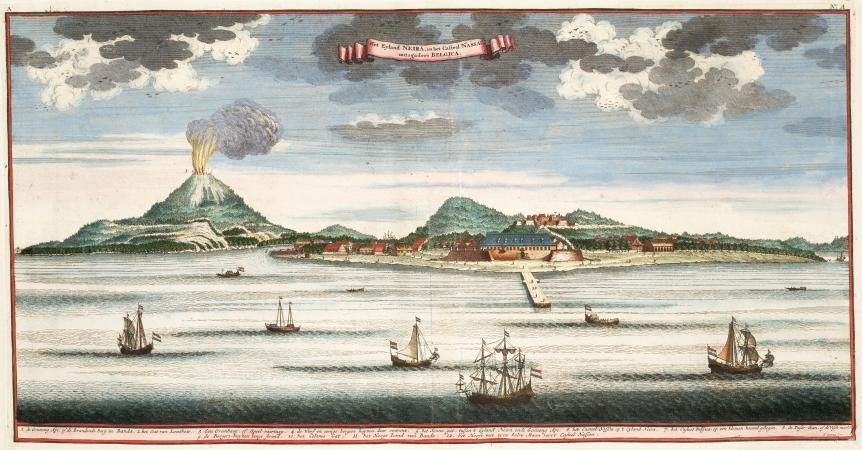
The conquest altered both the distribution of profit and the shape of trade. A network with many participants, in which goods passed through several hands and cultures, was forced into a pipeline with a controlled source and a controlled buyer. The older route had produced brokers, multilingual ports, borrowed words and shared habits because so many people touched the cargo. The monopoly became more profitable by removing those hands and preventing Bandanese sellers from choosing another way out. Ships continued to move, but bargaining power no longer travelled with the spice.
Banda prevents this maritime history from becoming a romance. Trade can join cultures while stripping producers of power, and a harbour can be crowded while its hinterland is being emptied. Tonnes and ship calls record movement, but movement says little about who controls the next transaction, owns the knowledge around it or retains the margin after the commodity leaves.
The Dutch increased their margin by reducing the number of hands allowed to touch the spice. Singapore would prosper by doing something closer to the reverse. Lacking a great commodity hinterland of its own, it allowed cargo to move freely and increased the number of useful transactions surrounding goods it neither grew nor owned.
How Singapore kept the interval
Seen after Banda, the boxes at Keppel Harbour reveal another way of retaining value along a route. In 2025, Singapore handled a record 44.66 million standard container units. In recent years, roughly nine out of ten containers passing through have been transshipment cargo, lifted from one vessel and placed on another on the way to a different country. Most neither begin nor end on the island.
Because Singapore owns neither the mine, farm or factory at the origin nor the consumer at the destination, transshipment might appear to be a weakness. Its achievement was to make the interval between them economically dense.
The decision to prepare for containerisation was taken in 1967, when the technology's future in Asian trade was not yet assured. Tanjong Pagar Container Terminal opened in 1972 with three berths, becoming only the second container terminal in Asia. Global container traffic accelerated a few years later, by which time Singapore was already waiting for it. Jurong Port grew alongside the industrial estate, making maritime infrastructure an instrument of industrialisation rather than simply a service to an economy already there.

Around every call gathered bunkering, ship repair, marine engineering, insurance, arbitration, broking, trade finance, logistics software and the regional offices of shipping groups. A vessel could refuel, a contract could be enforced, a feeder connection restored, a damaged engine repaired and a dispute settled. When a route broke down, Singapore could recover some of the time it had lost. Certainty became the port's most valuable product.
The cranes alone could not produce that reliability. By the end of 1965, the Housing and Development Board had built 53,000 flats, moving families with low incomes out of overcrowded settlements while a rapidly industrialising city reorganised land and transport around new estates. The port, public housing, technical school, customs desk and industrial estate were administered as parts of one production system. Public housing was therefore maritime infrastructure, although no ship appeared in the photograph. Singapore's most consequential hinterland was the society it assembled around the water.
There is an unexpected continuity between a Sadhaba, an Odia maritime merchant, reading the sky over the Mahanadi and a controller watching screens at Tuas. Both make a living from knowing when a vessel can move. The Sadhaba had to submit commerce to the calendar. Singapore spent decades building institutions that made the calendar more obedient to commerce.
Tuas extends that ambition through automation, electrified equipment and a planned annual capacity of 65 million standard container units across 66 berths. Its first phase was built five metres above mean sea level, while the port is being prepared for larger ships, fuels with lower emissions and higher seas.
Singapore's model is often described as a triumph of location, but many ports in equally favourable locations never became Singapore. Geography provided a harbour on a major route, while policy taught the economy around it how to earn from the same ship several times before it disappeared over the horizon. Where Banda concentrated value by constricting movement and removing hands, Singapore captured it by making movement reliable and adding capabilities around it.
The Dutch monopoly had been administered from Batavia. More than three centuries after Coen's conquest of Banda, when the Netherlands tried to recover the colony it had lost, Java became the point at which Odisha entered the story again. This time the vessel was a Dakota, and what crossed the blockade was not spice but political voice.
Odisha's second voyage
In July 1947, the Dutch were trying to suppress Indonesia's independence when Biju Patnaik flew into Java and carried Sutan Sjahrir out so that the Indonesian leader could make his country's case abroad. An old route once navigated by monsoon winds had returned as an act of Asian solidarity. This time, an Odia crossed the archipelago not in search of cargo, but to help a new nation speak beyond a blockade.
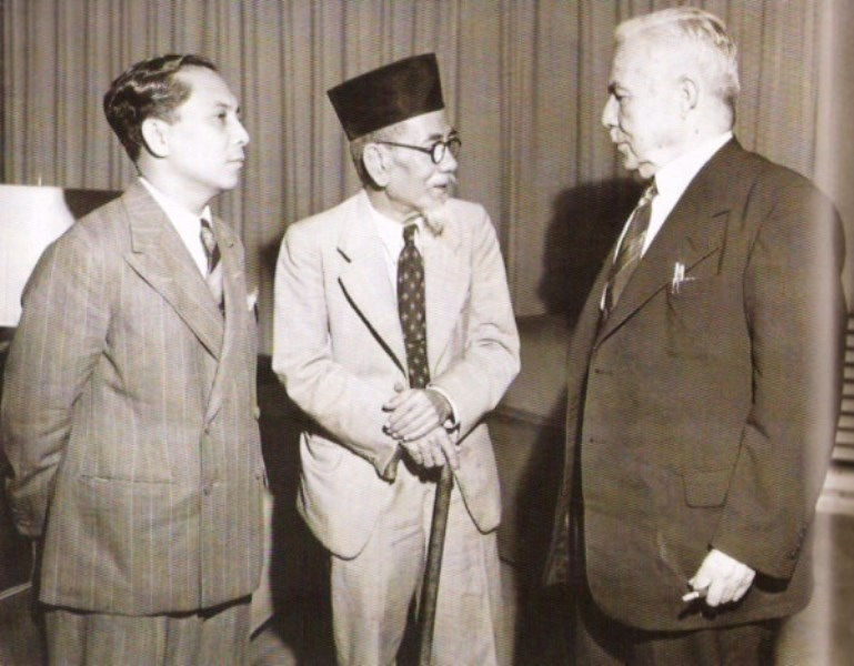
Years later, as chief minister, Patnaik became the driving force behind Paradip Port. Jawaharlal Nehru laid its foundation stone in 1962, and the port was commissioned in 1966. In that sequence, the connection between Odisha's maritime past and its industrial future became material rather than ceremonial. The man who had flown a Dakota over Java helped cut the state's largest modern opening to the sea.
Stand at that opening today and the scale is difficult to reconcile with the paper boats on the Mahanadi. Rail sidings, conveyors, storage yards and berths move coal, iron ore, crude oil, petroleum products and fertiliser materials towards ships whose holds dwarf the older vessels of memory. Odisha's ports handled 202.48 million tonnes of cargo in 2024-25. Paradip alone accounted for 150.41 million tonnes, the highest throughput among India's major ports that year, while the state handled roughly 13 per cent of the country's port cargo.
The figures settle the question of whether Odisha can move cargo at scale. Banda and Singapore leave a harder question behind, about how much value remains in Odisha after the cargo has gone.
Paradip has supported refining, steel, aluminium, fertiliser and other industries, while its railways, roads and employment have reshaped the region. Yet public ambition is still expressed largely through tonnes and capacity. Plans envisage Paradip expanding beyond 500 million tonnes a year alongside additional ports, shipbuilding and repair, and facilities for green hydrogen and ammonia. Each may be valuable, but the headline number treats every tonne as if it left the same economy behind.
A tonne of iron ore can pay a royalty, rail freight and port wages before becoming raw material in someone else's industrial system. Those are real gains, but they are not the same as the gains retained when local firms design equipment, certify a fuel, repair a vessel, write software or finance the shipment. The crane weighs both outcomes in tonnes, although one leaves a thicker economy behind.
That difference becomes harder to see when the cargo is new. A shipment of green ammonia may look futuristic and low in carbon emissions while reproducing the old mineral corridor if Odisha supplies the renewable power and the molecule but imports much of the equipment, knowledge and finance. A green port would retain more of the voyage by anchoring electrolyser manufacture, vessel conversion, fuel certification, storage technology, maritime finance and skilled maintenance in the state. Each would create another opportunity to earn before the ammonia reached open water. The commodity and the commercial system around it together determine how much value remains after the shipment has been counted.
Singapore offers a useful lesson, although Odisha’s circumstances are entirely different. A state of more than 45 million people, with mines, farms, forests, industrial towns and a long coastline, has little reason to imitate an island entrepôt built around importing other places’ goods and exporting them again. Its harbour can join the productive life of the interior to routes across the Bay of Bengal, treating Cuttack, Bhubaneswar, Paradip and the mineral districts as one economic geography rather than a sequence of places through which cargo merely passes.
That deeper hinterland would be built as much in classrooms, repair yards, contracts and homes as in rail lines. Smaller manufacturers would need reliable logistics and trade finance, marine engineering would require testing, certification and specialised training, and coastal towns would need housing and transit that allow families to build a life beside the industries expected to grow there. Singapore's experience matters because it treated these as parts of the industrial machinery rather than social additions to be supplied after success.
This also gives Bali Jatra a possible present tense. The Sadhabas left behind a festival, the anxiety inside Ta'poi's story and an areca nut whose ancestry may reach across the same sea that the ritual remembers. Biju Patnaik's flight placed a modern act of Asian solidarity on the old route between Odisha and the archipelago. Trade, research and culture can give that relationship a contemporary form, allowing Bali Jatra to operate as a marketplace for a connection still being made rather than a pageant of vanished glory.
Maps usually draw the harbour as a point facing the sea and the hinterland as the territory spreading inland from it, but the older Bay of Bengal suggests a more fluid geography. A harbour’s economic hinterland may also lie across the water among people who share a wind, a crop, a ritual or a commercial language, or within the institutions that make a distant ship trust a local contract. Singapore built such a hinterland through schedules, services and a society organised around the water. Dutch monopoly turned Banda’s into a territory of extraction, while Odisha’s once ran both up the Mahanadi and across the monsoon. Its modern form can do so again if passage through the harbour thickens the economy on shore instead of merely proving how efficiently cargo can leave it.
At Singapore's port, most container vessels complete cargo handling and refuelling within a day, leaving payments behind with terminal operators, brokers, financiers and insurers. At Cuttack, a child lowers a paper boat carrying a lamp, a leaf and a nut from plants whose ancestors may have travelled west along the same ocean centuries ago. The paper will soften and sink before morning, but the memory has proved remarkably seaworthy.
Sources and further reading
Singapore's 2025 port performance · mpa.gov.sg ↗
Singapore's port recovery model · mpa.gov.sg ↗
Singapore's early industrial strategy · sg101.gov.sg ↗
Public housing after independence · nlb.gov.sg ↗
Singapore's early container wager · mpa.gov.sg ↗
Monsoon winds and Odisha's maritime trade · drs.nio.res.in ↗
Bali Jatra and archaeological evidence · magazines.odisha.gov.in ↗
Excavations at Manikapatna · nature.com ↗
The Bali voyage chant and maritime memory · livehistoryindia.com ↗
Betel chewing across Southeast Asia · biblioasia.nlb.gov.sg ↗
The 1621 conquest of the Banda Islands · cambridge.org ↗
Biju Patnaik and Indonesia · indianembassyjakarta.gov.in ↗
The history of Paradip Port · paradipport.gov.in ↗
Odisha's port cargo in 2024-25 · shipmin.gov.in ↗
Economic plan for Odisha's coastal region · niti.gov.in ↗
Cover image. Ships and rowing boats in Singapore Harbour, c. 1870 to 1900. G.R. Lambert & Co., Rijksmuseum, public domain.


Comments